Loading... Please wait...

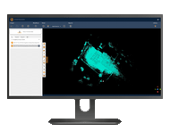
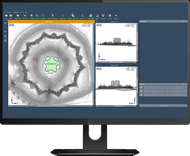
Volumes Software

Product Description
GeoSLAM Volumes Software
Stockpile volumes measurement made easy
Determine accurate stockpiles volumes measurements, silo reserves or mining tempos, without the need for GPS.
Walk and scan, or attach the scanner to a trolley, drone, pole, UAV or vehicle for remote monitoring or hazardous environments.
GeoSLAM Volumes software then instantly turns data into actionable 3D information for rapid, real-time decision making.
GeoSLAM Volumes Datasheet (CLICK HERE!)
Key Features:
- Perform accurate analysis of material on sites
- Ensure accurate reporting of mined materials
- Improve your supply chain and planning
- Easier stock takes and auditing
- More efficient than traditional topographic, photogrammetry or LiDAR scanning
What You'll Love About GeoSLAM
GeoSLAM ZEB FAMILY Brochure (CLICK HERE!)
-
More Competitive: Being able to offer rapid results to clients makes everything you do more competitive and gives you the potential to offer services to a wider degree
-
Ease of Use: GeoSLAM’s scanners can be used by anyone, so you don’t need to be a seasoned expert to create accurate 3D models
-
Go Anywhere: GeoSLAM can be used anywhere, from the tightest spaces to remote spots, without the need for GPS
-
Speed: If you can scan faster, you can work faster, maximizing your time and allowing you to determine layouts, calculate room size and produce floor plans within minutes
-
Continuous Data Collection: GeoSLAM’s scanners allow for continuous data processing, which means you can see individual measurements, including topographical details alongside key features
- Accuracy: From design, to construction and maintenance, GeoSLAM’s scanners can be used to quickly and accurately scan and collect data at each stage of a building’s development
- Create and Manage a Digital Twin: For true project collaboration, effortlessly and accurately create a digital twin of any built environment, both indoor and outdoor
Product Videos
Flythrough of data from a mine site, collected using a GeoSLAM ZEB family scanner.
-
 GeoSLAM Point ...Flythrough of data from a mine site, collected using a GeoSLAM...