


catch
PIX4DPlease Call for a Quote and to Setup a Free Demo at (724) 266-1600 or PLI@Laserinst.com
(No reviews yet)

Write a Review
PIX4D
catch
Transform Your Work with Precise 3D Scans & AR | Learn More (CLICK HERE!)
What Makes PIX4Dcatch the Best Solution?
- Georeferenced 3D Scanning
- PIX4Dcatch can create detailed and georeferenced 3D models using both photogrammetry and LiDAR technology from your smartphone.
- Versatile Processing Options
- Flexible solutions for processing, including direct upload to PIX4Dcloud for easy processing and/or export to PIX4Dmatic for advanced control.
- RTK Compatibility
- Achieve absolute centimeter accuracy in your 3D models with PIX4Dcatch and RTK.
- Innovative AR Features
- Use AR to easily detect GCPs and see as-built and CAD design overlays for construction analysis.
- Ease of Use
- Intuitive UI with comprehensive support makes it easy for all users to quickly master.
Learn How PIX4Dcatch Can Be the Right Fit for You
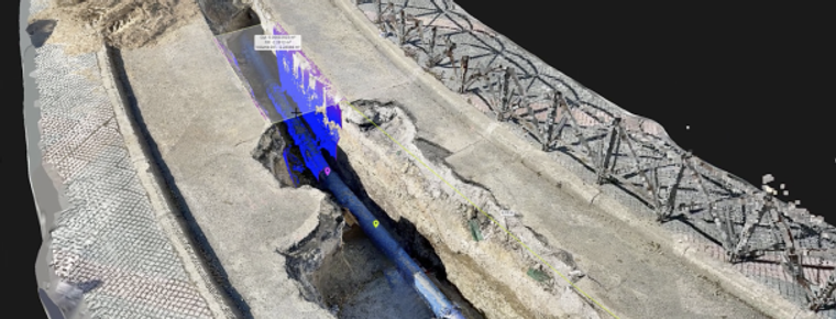
- Utilities & Subsurface Mapping
- Quick trench scans for documentation of subsurface utilities
- Visualization in AR, even after closure
- Save time and cut costs
- Construction Verification & Earthworks
- Overlay DXF, IFC, or SHP designs
- Measure & compare volumes
- Reduce costs, speed-up project timelines
- Civil Engineering & Site Verification
- Overlay CAD files for real-site comparison
- Cloud uploads for collaborative work
- Speed-up reviews, keep projects on-track
- Forensics Scene Capture
- Merge drone and phone data for 3D models
- Secure, offline, user-friendly workflow
- Detailed and comprehensive scene documentation
- Land Surveying
- Streamline surveying with a user-friendly interface
- Integrate with PIX4Dmatic and PIX4Dcloud
- Easy data processing and report sharing