null

Categories

Site Information

 Loading... Please wait...
  • Facebook LinkedIn Twitter YouTube News
  • Call us 724-266-1600
  • My Account

News

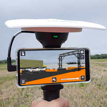
"What a GNSS Receiver Can Do for Underground Mapping Professionals!"

Posted by Precision Laser & Instrument, Inc. on

"What a #GNSSReceiver Can Do for #Underground #Mapping Professionals!" 

Read: https://bit.ly/3Pn5Ys8

Learn More: https://www.laserinst.com/juniper

#PLI Juniper Systems, Inc. #Geospatial #GeospatialData #GeospatialTechnology #GNSS #GPS #GIS #UndergroundUtilities #Utilities #UtilityMapping #UtilityManagement #Water #WaterManagement #WaterUtilities #PublicWork #PublicWorks #NaturalGas #NaturalGasIndustry #NaturalGasPipeline #UrbanPlanning #Telecommunications #PublicServices #Municipal #MunicipalServices

"Augmented Reality is a Reality!"

"#AugmentedReality is a Reality"Read: https://bit.ly/2VrIjQC#PLI #Geospatial #GeospatialData #Surveying #Surveyor #Surveyors #SurveyLife #LandSurvey #LandSurveying #ConstructionSurvey #Construciton #ConstrucitonLife #EngineeringLife #BIM #VDC #CAD #AIA #AEC #AGC #NSPS #OilandGas #OilandGasIndustry #Utilities #Infrastructure

Read More »


Fast High-Accuracy Mapping for Gas Pipelines!

"SUBURBAN CONSULTING ENGINEERS, INC., (SCE) utilizes #GIS technologies – including the #Trimble #R2 #GNSS with #TDC600 data collectors running #Esri #ArcGIS Collector software – for fast, high-accuracy #mapping for #gas #pipelines."Learn More: http://bit.ly/3aXgnI6Schedule a Local Solutions Demo!https://www.laserinst.com/locate-mapping-products724-266-1600 | PLI@laserinst.com#PLI #Geospatial #GeospatialData #Surveying #Surveyor #Surveyors #SurveyLife #GPS #URISA #AssetTracking #NSPS #PSLS #PLSO #WVSPS #PA #OH #WV #UtilityMapping #EngineeringLife

Read More »